Don’t focus only on radar specs—what perception system does a robot project really need?
Don’t Just Look at Radar Specs—What Perception System Does a Robot Project Actually Need?
Summary
Click “Computer Vision Life”, select “Star” to get robot AI insights instantly. Don’t just look at radar specs—what perception system does a robot project actually need? From data collection and SLAM to navigation and interaction, choosing the right perception for robot projects.
Click “Computer Vision Life”, then select “Star”
Robot AI insights delivered instantly
Don’t just look at radar specs; what perception system does a robotics project actually need?
From Data Collection and Mapping to Navigation Interaction
When selecting a perception system for a robot project, many people’s first reaction is to compare radar range, point‑cloud density, and field of view. However, once integration actually begins, the factors that determine whether the project can run smoothly often include time synchronization, localization method, edge computing power, communication interfaces, and the degree of software openness.
Another easy‑to‑overlook issue is: do you need a data‑collection device, or a perception system that will be permanently mounted on the robot for real‑time operation? The former is responsible for gathering data, while the latter must continuously perform localization, mapping, environmental perception, and navigation support as the robot moves.
MetaCam EDU, EDU‑SCAN, EDU‑D360, and EDU‑BOX each occupy different positions in this workflow. Clarify the task first, then look at the specifications, and the selection becomes much simpler.
Most teams encounter similar issues when they first work with robot perception devices:
Want to do robot navigation, do you need to buy scanning equipment?Want to research SLAM, do you need to build your own sensors?Want to create digital twins, use handheld scanning or a robot platform?Already have a robot chassis, how to quickly build a perception system?
In fact, different tasks have completely different equipment requirements.
Some devices address:“help people collect spatial data.”
Whereas other devices address: “enable robots to understand space and make decisions based on the environment.”
This is also the part that gets most confusing when choosing a device.First, consider what your goal is
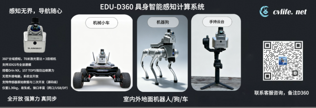
From sensor fusion to real‑time positioning and navigation, meet the EDU‑D360. It doesn’t just pack a radar into a housing; it integrates laser, vision, inertial, RTK, edge computing, and an open software environment into a single device, providing the continuous spatial perception capability needed for quadruped robots and mobile robots.
Why a robot project needs a complete perception system
When a development team builds a robot perception module from scratch, they usually have to purchase radar, camera, IMU, computing platform, power supply, and communication modules separately, and then handle mechanical installation, calibration, time synchronization, driver adaptation, and thermal management. Just because the hardware is powered on does not mean the data is ready for fusion.
Especially when a quadruped moves quickly, climbs stairs, or walks through dynamic crowds, the time offsets between sensors are amplified. Motion blur in the camera and mismatched radar and image data both degrade localization and environmental understanding.
EDU-D360’s approach is to integrate these steps in advance, allowing teams to spend less time repeatedly building hardware and focus their effort on SLAM, navigation, target recognition, and embodied intelligence algorithms.
Dual 360-degree perception covering the robot’s surrounding environment
EDU-D360 uses the Livox Mid-360 LiDAR, providing 360° horizontal point‑cloud coverage. The LiDAR is mounted with a ground‑tilt, allowing it to observe the front, rear, and sides while also covering the area near the ground and structures above.
The vision subsystem consists of three global‑shutter industrial cameras. Together they cover 360° horizontally. Global shutters reduce the common jelly‑roll effect and motion blur when the robot moves, making the images better suited for visual localization, object detection, and semantic understanding.
The LiDAR reliably captures spatial geometry, while the vision system provides color and semantic information. Working together, the two sensor types give the robot not only obstacle distances but also an understanding of what is around it.
Hardware synchronization truly aligns multi-sensor data
The most underestimated aspect of multi‑sensor fusion is time synchronization. EDU‑D360 places the LiDAR, camera, and IMU in the same clock domain, maintaining consistent timestamps through hardware triggering.
When the robot is moving quickly, turning, or experiencing vibrations, strictly synchronized data better supports LiDAR‑inertial, visual‑inertial, and LiDAR‑visual‑inertial fusion. For algorithms such as FAST‑LIO2 and FAST‑LIVO2, this reduces the extra effort the development team must spend handling soft synchronization errors.
Edge-side computing enables perception results to be used directly for action
The EDU-D360 is equipped with an NVIDIA Jetson Orin NX SUPER. It delivers 157 TOPS of AI compute power and comes with 16 GB of memory and 256 GB NVMe storage.
This compute capability is not only used for running SLAM, but can also deploy models such as object detection, semantic segmentation, and depth estimation. The robot can perform perception and inference locally, without having to send all raw data back to an external industrial PC or the cloud and wait for results.
The device supports PyTorch, TensorRT, CUDA, and Docker. Developers can deploy their own algorithm environment on the device, and can also transmit real-time data and computation results to the robot controller via gigabit Ethernet.
Camera can be developed (e.g., license plate recognition)
Key Modules Required for an Integrated Device Robot
-
Open data and system facilitate further development
EDU-D360 is not a closed device that can only invoke fixed functions. Raw data such as LiDAR, camera, IMU, and RTK can be used for algorithm development, and can be saved and exported via rosbag. The system also provides a Docker environment, operation documentation, and secondary development resources.
In terms of algorithms, it supports integration with visual‑inertial SLAM, multi‑sensor fusion SLAM, and frameworks such as FAST‑LIO2, FAST‑LIVO2. When developing 2D/3D maps, autonomous obstacle avoidance, and path planning, it can also be paired with a robot navigation SDK.
-
Installation and power supply are also considered for robot platforms
Traditional handheld scanners mounted on robots often require modifications to the handle, battery, and mounting structure, as well as additional external computing power and power supply. The EDU-D360 is designed from the outset for quadruped robots and mobile chassis.
The device uses the standard Aka interface, making installation and removal across different platforms easy; it can run independently on its built‑in battery or be powered externally by the robot. An aluminum alloy integrated body, active cooling, and IP5X protection support longer continuous operation.
Aka Quick‑Mount
What robot projects can it be used in
-
Robotic Dog Campus Inspection
In environments that combine outdoor trails, indoor corridors, stairs, and low obstacles, the EDU-D360 can provide real-time mapping, positioning, and environmental perception data, supplying input for the robotic dog’s autonomous inspection and obstacle avoidance.
Embodied Intelligent Navigation Development
The lab can run SLAM and AI models simultaneously on the device side, linking target recognition, spatial positioning, path planning, and robot control into a complete workflow, used to validate embodied intelligent navigation solutions.
-
Mobile Robots and Industrial Inspection
For wheeled robots, unmanned vehicles, and inspection platforms, the EDU-D360 can serve as an independent perception and positioning module, connecting to the control system via Ethernet, and combined with RTK and multi‑sensor fusion algorithms to cover outdoor tasks.
EDU BOX adds the human-computer interaction component
After the robot acquires positioning and navigation capabilities, on‑site personnel still need a more direct way to operate it. EDU‑BOX is an interactive extension terminal for EDU‑D360 and mobile robot applications.
It supports image data transmission, handheld remote control, physical buttons, offline voice, remote shouting, and extensible 4G communication. “Super Dock” is officially released, EDU‑BOX moves toward real‑world deployment, enabling robots to go from “can walk” to “can work” and accelerating development. Operators can control robot movement via the remote, as well as quickly start mapping, stop mapping, mark target points, and issue navigation tasks.
EDU-BOX connects perception, navigation, and on-site operations.
From Data Collection to Real-Time Robot Perception
Centered on spatial perception and multi-sensor fusion, the product lineup also includes MetaCam EDU and EDU‑SCAN. They focus more on 3D data acquisition, forming a different tier of product combination with the robot‑online‑operation oriented EDU‑D360.
MetaCam EDU for teaching, research and handheld scanning
MetaCam EDU is a handheld 3D spatial scanner education version, integrating Livox Mid-360 LiDAR, stereo fisheye camera, six‑axis IMU and RTK. The stereo camera covers about 270°×180°, laser ranging is about 40 m to 70 m under different reflectivity conditions, and the whole device weighs about 1 kg.
The device supports a mobile app for real‑time preview of colored point clouds and saves data in rosbag format. In addition to the hardware itself, the product includes secondary‑development content for visual‑inertial SLAM, multi‑sensor fusion SLAM, 3D Gaussian Splatting, as well as operation documentation, video courses, and technical support.
This combination is more suitable for university courses, laboratory research, and algorithm introductions. Users can start from data acquisition and gradually complete point cloud reconstruction, visual‑inertial localization, multi‑sensor fusion, and 3DGS experiments, without having to spend a lot of time building acquisition equipment themselves.
EDU SCAN for Ultra‑Long‑Distance and Multi‑Platform Capture
EDU-SCAN further expands to more distant and larger job scenarios. It uses ultra‑long‑range LiDAR, with a maximum ranging distance of 450 m for data labeling, point‑cloud output up to 720,000 points per second, and is equipped with an industrial‑grade global‑shutter camera and a 200 Hz six‑axis IMU.
The device supports hardware synchronization of LiDAR, camera, and IMU, and provides Gigabit Ethernet and an external hardware trigger interface. Weighing about 960 g, the body can switch between handheld, vehicle‑mounted, robot, and drone platforms, and can also be used with a gimbal for high‑altitude large‑scene acquisition.
In scenarios such as high‑rise buildings, urban blocks, large construction sites, tunnels, mines, and underground spaces, EDU‑SCAN places greater emphasis on long‑range acquisition, SLAM capability in GNSS‑denied environments, and open data interfaces. It can serve both as a professional scanning device and as a platform for developing and validating robotics, UAVs, and 3D reconstruction algorithms.
From a product division perspective, MetaCam EDU helps teaching and research teams quickly start 3D data collection and algorithm experiments, EDU‑SCAN extends the acquisition capability to ultra‑long distances and multiple platforms, and EDU‑D360 deploys perception, synchronization, and computing capabilities permanently on the robot body. Together, the three products cover the complete workflow from data acquisition and algorithm development to real‑time robot operation.
The value of perception systems ultimately must be reflected in robot actions
Robotics projects require not just a higher‑spec radar, but a perception system that can reliably collect data, synchronize strictly, compute in real time, be easy to integrate, and support ongoing development.
What EDU‑D360 aims to solve is exactly the engineering gap between sensor data and robot actions. It turns perception hardware from a scattered collection of components into a spatial perception and computing module that can be directly integrated into quadruped and mobile robots.
Contact and Communication
If you are planning robot navigation, 3D data acquisition, drone surveying, or embodied intelligence projects and need information on product configurations, purchasing options, platform integration, or secondary development, feel free to contact us. We can discuss more suitable products and implementation plans based on specific scenarios, carrier platforms, and algorithm requirements.
Qiqi
Get MirrorSpeed