What does project implementation entail?
What Does Project Implementation Involve?
Summary
Click “Computer Vision Life”, select “Starred” to receive AI robot insights instantly—a robot platform’s value should not stop at the lab. It should provide an open algorithm verification environment for universities and R&D teams, and also be able to
Click “Computer Vision life”, then select “Star”
Robot AI insights delivered instantly
A robot platform’s value should not stop at the laboratory. It should not only provide an open algorithm verification environment for universities and R&D teams, but also serve as a finished kit that can enter real-world scenarios, offering a reliable carrier for intelligent inspection, environmental perception, and industry project implementation.
Recently, we demonstrated the camera AI recognition capability of this intelligent off‑road vehicle platform. In the video, you can see the camera capturing the environment in real time and, combined with AI algorithms, performing object detection and recognition.
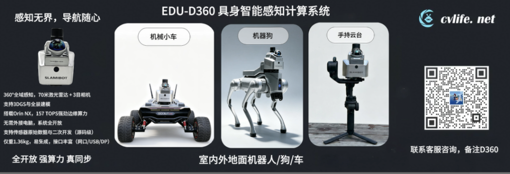
Behind this capability is a robot development platform composed of a mobile chassis, EDU‑BOX, and the EDU‑D360 omnidirectional vision system. It links environmental acquisition, fused positioning, AI inference, navigation development, and motion execution, providing a foundation for subsequent applications such as autonomous navigation, intelligent obstacle avoidance, target tracking, and mobile inspection.
It can serve universities, laboratory teams, and robot developers, helping teams overcome the most time‑consuming and error‑prone stage between algorithm demos and real‑robot validation; it can also function as a configurable and extensible ready‑made kit, providing a mobile robot foundation platform for system integrators, industry solution teams, and inspection project owners.
Why do robot projects often get stuck at the “last mile”?
Many visual algorithms achieve good results on public datasets, but once deployed on mobile robots, problems start to appear one after another:
-
Cameras are unsynchronized, causing temporal misalignment during robot motion, which affects localization, mapping, and multi‑view fusion; -
Insufficient field‑of‑view coverage: the front can be recognized, but the side and rear become perception blind spots; -
All image data is streamed back to the host, quickly making bandwidth, latency, and compute resources a bottleneck; -
Cameras, compute platforms, chassis, and ROS nodes are each independent, and interface integration consumes a lot of development time; -
Algorithms can run on a computer, but are hard to reproduce stably under real vibrations, lighting changes, and complex terrain.
These issues may seem hardware-related, but ultimately affect project timelines, product development cycles, and delivery quality. A platform truly suitable for R&D and application needs to address five things simultaneously: “see everything, capture accurately, compute efficiently, connect reliably, and run stably”.
Dual 360° omnidirectional perception + 157 TOPS edge computing power: enabling robots to see everything and compute quickly
EDU-D360 integrates multiple sensors and an edge computing platform into a single unit, equipped with a Livox Mid-360 LiDAR that offers a 360° horizontal field of view, and three global shutter cameras covering a 360° horizontal visual range, forming a “LiDAR 360° + Vision 360°” dual‑360° perception architecture. In simple terms, the LiDAR measures the distance and spatial structure of surrounding objects, while the triple‑camera system captures environmental images from different directions, providing visual data for recognizing targets such as people, vehicles, equipment, and roads.
The three‑camera system has a single‑frame resolution of 1920×1200, with each camera’s field of view being 136° diagonal, 130° horizontal, and 101° vertical, and a frame rate of 10 Hz (up to 60Hz). The global shutter helps reduce image distortion caused by robot turning, jolting, and rapid motion, providing more stable images for object detection, feature matching, and visual positioning. In practical use, this means the robot can observe its environment more reliably while moving.
LiDAR, a stereo camera, and a 200 Hz six‑axis IMU are hardware‑synchronized and work together with an RTK positioning module. The IMU is used to sense the robot’s steering, acceleration, and attitude changes, while the RTK can provide high‑precision position references in suitable outdoor environments. Operating multiple sensors under a unified time base helps reduce data misalignment, providing a more reliable data foundation for laser‑visual fusion, SLAM mapping, robot localization, dynamic target detection, and path planning.
The device is equipped with an NVIDIA Jetson Orin NX SUPER, featuring 16 GB of memory and 256 GB NVMe storage, with AI compute power up to 157 TOPS, supporting development environments such as PyTorch, TensorRT, CUDA, and Docker.In plain terms, it is like giving the robot a high‑performance computer that can run on the vehicle, allowing algorithms for object detection, semantic segmentation, depth estimation, 3D perception, and SLAM to execute directly on the device without constantly sending large amounts of data back to an external computer for processing.
For developers, this configuration can directly provide multi‑source data such as LiDAR point clouds, stereo images, IMU, and RTK, making it easy to deploy their own models, debug algorithms, and conduct on‑vehicle validation; for actual use, it helps the robot perceive the environment more promptly, achieve localization and navigation, and provides a foundation for photo transmission, remote inspection, and subsequent business feature development.
Stereo vision + edge AI, what can it specifically achieve?
The three‑camera global shutter system not only captures images, but also provides about 4 TOPS of compute power on the camera side, with roughly 1.4 TOPS dedicated to AI inference and the remaining compute used for image processing, depth calculation, and video encoding. The camera can first perform image correction, depth processing, and preliminary object detection, after which the Orin NX SUPER built into the EDU‑D360 handles complex model inference, laser‑vision fusion, SLAM, and navigation calculations. This two‑tier edge‑computing architecture reduces system load, shortens processing pipelines, and supports secondary development of algorithms such as YOLO, OCR, and pose estimation, providing a foundation for robot localization, obstacle avoidance, and inspection applications..Cameraand edgecomputing platform collaborate, enabling the development of the following capabilities according to project requirements:
-
Object Detection and Classification: Identify people, vehicles, equipment, containers, and other specified targets, and output their category, confidence score, and image location
-
Multi‑Direction Environmental Recognition: Simultaneously use three camera feeds to observe different directions, reducing the field‑of‑view limitation of a single forward‑facing camera
-
Object Tracking: Continuously detect moving personnel or objects, providing data for following, avoidance, and behavior analysis
-
Device Status Recognition: Train models for instrument panels, indicator lights, switch states, or specific device appearances, used for inspection data collection
-
Semantic Segmentation and Traversable Area Analysis: Distinguish road, wall, grass, stairs, obstacles, etc., to help robots understand the scene
-
Anomaly Detection: Identify foreign objects, unauthorized personnel, equipment appearance anomalies, and other situations based on specific business data
-
Laser‑Vision Fusion: Combine category, color, and texture information from cameras with spatial structure and distance data from LiDAR to provide richer environmental information for localization, mapping, obstacle avoidance, and navigation.
Therefore, the AI recognition shown in the video is only a part of the full capability. The recognition results can also be linked with time, location, inspection tasks, and on‑site images, providing a data foundation for anomaly alerts, inspection records, and subsequent reviews. Which objects can be recognized and the achievable accuracy depend on the deployed model, training data, and actual operating environment.
To lower the usage and debugging barrier, the EDU‑D360 also offers a mobile app that can view real‑time colored point clouds, SLAM trajectories, RTK signals, sensor status, and device battery level, and supports adjustments of image exposure, gain, and other parameters. The device uses a standard Akka quick‑mount interface, allowing rapid installation on mobile chassis, quadruped robots, and other carriers; its integrated aluminum alloy body, active cooling, and IP5X protection make it more suitable for long‑term online robotic operation rather than just a handheld data‑collection scanner.
From perception cerebellum to the whole vehicle: putting algorithms into a real closed‑loop for validation,forming a complete vehicle chain
Whether a robot product is suitable for development and project validation cannot be judged solely by sensor specifications and computing power; it must also be assessed whether perception, interaction, navigation, and motion execution can form a complete chain.
In the whole‑vehicle system, the EDU‑D360 handles environmental perception, data collection, and edge computing; the navigation system is responsible for mapping, localization, and path planning; the EDU‑BOX takes care of image transmission, handheld remote control, voice interaction, 4G communication, task dispatch, and status feedback; and the mobile chassis executes motion commands and reports odometry. These four components together form a complete chain from perception and task interaction to motion execution.
EDU-BOX is not just a simple external box. Operators can use the 7‑inch handheld remote to view maps, point clouds, and three camera feeds, performing manual driving, emergency stop, waypoint setting, task dispatch, and, when necessary, manual takeover; it also supports remote voice prompts and status checks via the telemetry link. Voice interaction can be used for mapping, waypoint navigation, and motion control, with specific usage conditions depending on software configuration and network environment.
Thus, an algorithm can undergo a more complete validation process:
1. Complete model training or algorithm prototyping in the lab;
2. Perform offline debugging with real multi‑camera data;
3. Integrate the algorithm into a ROS node and run it in real time on the vehicle;
4. Let the perception results participate in navigation, obstacle avoidance, or task decision‑making;
5. Repeatedly test under different speeds, lighting conditions, terrains, and mounting configurations;
6. Continue iterating based on error, latency, and stability results.
This pipeline expands “model accuracy” into an evaluation of the entire system: whether detection is timely, localization is stable, data are synchronized, performance is reliable during motion, and control forms a closed loop. For research teams, these processes not only support experiments and comparisons in papers but also build reusable engineering foundations for competitions, joint projects, prototype deliveries, and technology transfer.
From development platform to inspection suite: bringing capabilities truly on site
When the platform moves from the laboratory to real-world scenarios, it can serve as a mobile perception carrier, continuously capturing environmental images from multiple directions along a task route, and using visual models to perform target recognition, obstacle detection, equipment status monitoring, and inspection record keeping.
For example, in settings such as campuses, warehouses, laboratories, server rooms, or factories, the following capabilities can be expanded based on actual needs:
-
Autonomous movement and route inspection: Based on preset maps and task points, perform scheduled, fixed-point or cyclic inspections -
Personnel and Obstacle Detection: Detect personnel, vehicles, or other obstacles on inspection routes, providing basis for slowing down, detouring, and alerts; -
Exception information retention: Record exception screenshots, timestamps, locations, and task results for later review and analysis; -
Multi-sensor expansion: Add thermal imaging, gas, temperature/humidity, acoustic and other sensors according to the scenario to create more comprehensive inspection data; -
Image Transmission and Remote Announcements:Transmit images, data, and device status via EDU-BOX, and use the speaker for remote broadcasting
<li
We provide a complete foundation for perception, computing, motion, and secondary development, and open sensor data, computing systems, and related development interfaces. Users can independently deploy models, develop algorithms, and integrate business systems around specific needs such as instrument recognition, anomaly detection, automatic recharging, and cloud management, allowing the same hardware platform to continuously adapt to different research projects and inspection applications.
Targeting research and industry, what directions can be pursued?
1. Laser-Visual Fusion SLAM and Visual-Inertial Localization
Conduct VIO and multi‑camera joint calibration research using stereo vision and IMU data, and explore multi‑sensor fusion SLAM by combining LiDAR, vision, and IMU. The supporting resources are compatible with mainstream frameworks such as FAST‑LIVO2 and FAST‑LIO2, facilitating algorithm verification, parameter tuning, and secondary development.
2. Multi-directional Perception and Complex Environment Navigation
Focusing on scenarios such as the robot’s rear-side blind spot, narrow passages, and outdoor unstructured roads, we conduct research on depth estimation, traversable area analysis, dynamic obstacle detection, and local planning.
3. Multi-Object Detection, Tracking, and Spatial Localization
Deploy custom neural networks to the edge, combining multi‑view images and depth information to achieve object recognition, continuous tracking, distance estimation, and spatial coordinate output, suitable for research and applications such as inspection, security, warehousing, campus management, and service robots.
4. Multimodal Data Collection and Dataset Construction
By leveraging multi-camera hard synchronization and a high-frequency IMU, we collect images and inertial data with a unified time reference, for building custom datasets, algorithm benchmarking, model training, and reproducing complex scenarios.
5. Robotics Courses and Engineering Practice
The platform simultaneously covers sensors, embedded AI, ROS, computer vision, SLAM, path planning, and chassis control, and can be used for graduate research projects, undergraduate comprehensive practice, robotics competitions, and industry‑academia joint experiments. Students no longer face isolated knowledge points, but a real system that can be continuously iterated.
A complete vehicle platform that balances usage and development
Whether it’s a research project or an industry initiative, purchasing equipment is only the beginning. The truly costly expenses often stem from wrong selections, incompatible interfaces, redundant integration, unstable data quality, and algorithms that cannot be transferred from computers to real equipment.
The intelligent off‑road vehicle platform, composed of the EDU‑D360, EDU‑BOX, and a mobile chassis, integrates LiDAR, stereo vision, IMU, RTK, edge AI, data transmission, handheld remote control, and a motion chassis into a single development framework. It not only opens sensor raw data, computing environments, and development interfaces, but also provides a complete vehicle foundation for direct experimentation and functional verification.
This means the R&D team can devote more time to core issues such as positioning, perception, and decision‑making; system integrators and project teams can also, based on existing vehicle capabilities, develop AI recognition, inspection workflows, and business systems tailored to specific scenarios.
From ‘seeing the environment’, to ‘understanding the environment’, and then ‘acting based on the environment’, this is the complete pathway required for deploying intelligent robot projects.
If you are conducting research on integrated SLAM, autonomous navigation, visual obstacle avoidance, multi‑camera fusion, edge AI, or mobile robotics, or if you need a full‑vehicle platform for developing inspection functions in campuses, warehouses, laboratories, data centers, and factories, you are welcome to learn more.
The platform provides open data, development APIs, and supporting documentation. Users can independently complete model deployment, algorithm development, and system integration based on inspection routes, target objects, communication methods, and business processes, enabling research results to be continuously validated and iterated on real mobile robots.
</h2
New Arrivals
Recommended Reading
Detailed introduction! Ultra‑long‑range EDU‑SCAN 3D LiDAR scanner, born for an open ecosystem!
Breaking Release! Unlock Hundred-Meter-High Drone Mapping!
Breaking Release! Rebuild a Hundred-Meter Tall Building in 2 Minutes!
Major release! Empowering robot dog SLAM and reconstructing the 3D world!
SLAM challenge! EDU-SCAN clearly reproduces a massive indoor electronic screen
SLAM Challenge! Reconstruct 10,000 in 9 minutes
This research tool smoothly reproduces the strongest SLAM: Fast-LIVO2!
Feed icon:
Feed bookmark icon:https://www.google.com/s2/favicons?domain=https%3A%2F%2Fwww.decemberpei.cyou%2Frssbox%2F
Collection task ID: 164
Get MirrorSpeed
Get MirrorSpeed